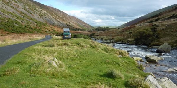
Penrith - Middle Eden Valley drive
A drive around Penrith and the unspoilt Eden Valley that features a number of historic buildings and prehistoric monuments. The scenic and gently undulating route also leads through some lovely old sandstone built villages, typical of this area. 45 miles.
Route Map
Summary of main attractions on route
| Distance | Attraction | Car Park Coordinates |
| 0 miles | Penrith | N 54.66496, W 2.75523 |
| 2.2 miles | Rheged Visitor Centre | N 54.64782, W 2.78089 |
| 4.1 miles | Dalemain House & Gardens | N 54.63466, W 2.80809 |
| 6.4 miles | Dacre Village | N 54.63187, W 2.83961 |
| 10.4 miles | Greystoke Village | N 54.66991, W 2.86841 |
| 14.8 miles | Hutton-In-The-Forest | N 54.71708, W 2.83822 |
| 22.1 miles | Eden Bridge picnic site | N 54.75544, W 2.70107 |
| 25.3 miles | St Michael’s Church | N 54.73828, W 2.66210 |
| 26.2 miles | Little Meg Stone Circle | N 54.73102, W 2.65655 |
| 27.2 miles | Long Meg Stone Circle | N 54.72735, W 2.66714 |
| 35.8 miles | Acorn Bank | N 54.64710, W 2.60235 |
| 41.2 miles | Brougham Castle | N 54.65446, W 2.71662 |
| 42.2 miles | Brougham Hall | N 54.64831, W 2.73221 |
| 42.6 miles | King Arthur’s Round Table | N 54.64810, W 2.73927 |
| 43.0 miles | Mayburgh Henge | N 54.64722, W 2.74519 |
| 45.0 miles | Penrith | N 54.66496, W 2.75523 |
The attraction car park coordinates are available as Points Of Interest (POI) files for your sat nav device. Use the following link to download a zip file containing the most common POI file formats; Penrith – Middle Eden Valley POI. Further information on sat nav files can be found on the Navigation page.
The Drive
Penrith

Distance: 0 miles
Location: Penrith, Bluebell Lane car park
Coordinates: N 54.66496, W 2.75523
Penrith is a busy market town on the eastern edge of the Lake District. It is an important hub for Eastern Cumbria being at the junction of the M6 and the A66, as well as having a railway station on the main west coast line. The location makes it a busy thoroughfare for traffic, but despite this the town centre retains a certain amount of charm and is worth exploring. The old town centre buildings are mostly local red sandstone which epitomises many of the buildings in this area. There are plenty of old streets and shops to explore and Penrith Museum, housed within the Tourist Information Centre, will tell you more about the area and its history. The attractive St Andrew’s Church is just off the market square and up the hill from there, opposite the railway station, is the 14th century Penrith Castle which is now in ruins but the remains are interesting and free entry. Car park is pay and display with nearby public toilets.
Travelling
Leave the car park and at the T junction turn left up the hill. Soon pass Booths supermarket on the right and Morrisons supermarket on the left. Take the second exit at the Morrisons mini-roundabout, then very shortly, third exit at the next mini-roundabout. Pass Penrith Castle immediately on the left and carry on along the A592 towards the M6. After approx 0.4 miles, pass Cranstons food store on the right and take the first exit at the following mini-roundabout. This soon leads to traffic lights at the giant M6/A66 roundabout. The right lanes are marked ‘A66W’ and you can follow these to take the third exit which is the A66 towards Keswick. The dual carriageway A66 leads for approx 0.8 miles, passing a Burger King, Greggs and Travelodge on the left, to reach another big roundabout. The first exit leads to the Rheged Visitor Centre.
Rheged Visitor Centre

Distance: 2.2 miles
Location: Rheged Visitor Centre
Coordinates: N 54.64782, W 2.78089
Rheged is an interesting visitor centre with a good selection of attractions for the whole family. It is apparently Britain’s largest grass covered building and the clever design certainly hides it from the surrounding countryside. There are various different shops, childrens play areas, cinemas, exhibitions on the local area and events. There are a few picnic tables and a play area outside, everything else is inside. Parking and entry is free for visitors, with cafes and toilet facilities inside. Open daily.
Travelling
Return to the A66 roundabout where you take the first exit which is the A592 towards Ullswater. The road follows the scenic River Eamont valley for approx 1.5 miles until a signposted private road on the right takes you the short distance to Dalemain House.
Dalemain

Distance: 4.1 miles
Location: Dalemain House & Gardens
Coordinates: N 54.63466, W 2.80809
The historic estate of Dalemain lies midway between Penrith and Ullswater. The house has an interesting history with different parts and various artefacts being added at different times. The attractive front of the house is actually a Georgian façade but some parts of the building are several centuries old. In more recent years it has built up some quirky connections with marmalade and even hosts the ‘annual world marmalade festival’! You can pay to tour the house and/or gardens, with a cafe, gift shop and free car parking for visitors. The attraction is open daily, except Saturday, from Easter to October.
Travelling
Return to the A592 and turn right towards Ullswater. The road runs alongside the River Eamont and you can see the hills surrounding Ullswater in the distance. After approx 1 mile, take the first right turn, signposted to Dacre. After approx 0.8 miles there is a small layby on the right alongside Dacre Beck where there is a picnic table adjacent to the river. Continue driving over the road bridge where you enter the village of Dacre. Drive up the hill, passing through the village, until you reach the Horse & Farrier pub on the left. There is roadside parking opposite the pub.
Dacre

Distance: 6.4 miles
Location: Dacre Village
Coordinates: N 54.63187, W 2.83961
Dacre is an attractive small village with some historic connections that are worth stopping for. St Andrew’s Church occupies the site of a former monastery and has a lovely churchyard with benches to enjoy the surroundings. Beyond each corner of the church can be found the Dacre Bears which are four weather beaten carvings apparently telling the story of bears sleeping, being attacked by a cat, grabbing the cat and eating the cat. From the churchyard you can see nearby Dacre Castle which in fact is a 14th century Pele Tower. It is now a private residence on the Dalemain Estate but a nearby footpath runs past the building for a better view. The Horse & Farrier pub in the village is a traditional Lakeland Inn and provides refreshments. Parking in the village is opposite the pub where there is a free layby but there are no public toilets.
Travelling
Continue up the hill leaving the village behind. After approx 0.8 miles the road meets the main A66 at a T junction. Turn left towards Keswick on the A66 which is dual carriageway. After approx 0.8 miles, take the right turn towards Greystoke, just before the end of the dual carriageway. Follow the narrow road through pleasant farmland for just over 1.5 miles to a T junction where you turn right on the B5288. Shortly, enter the village of Greystoke and continue to the village green on the left. Beyond this the main road bears right and the village car park is a short distance on the right.
Greystoke

Distance: 10.4 miles
Location: Greystoke Village car park
Coordinates: N 54.66991, W 2.86841
Greystoke is a pleasant historic village centred around the village green and ancient market cross. The impressive gateway off the northern side of the green leads to Greystoke Castle which runs various activities but unfortunately has no public access and no connection with Tarzan! The village has a heated open air swimming pool which is open to the public from May to September. Overlooking the village green is the Boot & Shoe pub which serves refreshments in traditional surroundings and there is a small village shop with Post Office. Nearby is the historic St Andrew’s Church which contains some interesting artefacts. Parking is free but there are no public toilets.
Travelling
Leaving the village car park, turn left towards the village green, then immediate right towards Blencow. Beyond Greystoke, soon pass the impressive Blencowe Hall on the left, a castellated manor house which is now holiday rental accommodation. The small village of Blencow is just beyond with its pretty village green and riverside access. Continue for approx 1.8 miles, with some far reaching views towards the Pennine hills, to enter the village of Unthank and shortly meet a T junction with the B5305 where you turn right towards Penrith. After approx 0.3 miles, the entrance to Hutton-In-The-Forest is signposted on the right.
Hutton-In-The-Forest

Distance: 14.8 miles
Location: Hutton-In-The-Forest
Coordinates: N 54.71708, W 2.83822
Hutton-In-The-Forest is a magnificent stately home and estate owned by Lord Inglewood. The enormous house has been built over a number of centuries, starting life as a medieval stronghold and built around the old Pele Tower. A tour of the house is well worthwhile as are the lovely gardens, especially the walled garden. There is a fee for access to the house and gardens which includes car parking, a cafe and toilet facilities. The house and cafe are only open Weds, Thurs and Sundays from Easter to October. The gardens are open every day except Saturdays, Easter to October. There are also various events on during the summer months.
Travelling
Leave the car park and turn right, back on the B5305 towards Penrith. After approx 0.5 miles, take the left turn signposted to Plumpton. This road soon crosses the M6 motorway before entering the village of Plumpton. At the far end of the village is a cross roads with the main A6. Go straight across the A6 on the B6413 towards Lazonby. Continue for approx 3 miles on the elevated open road with good views of the Pennines ahead, before the road descends towards Lazonby and soon enters the village. Continue through the village, passing the entrance to Lazonby & Kirkoswald railway station on the left, just before a small supermarket on the right and the Midland Hotel pub on the left. Pass under the Settle to Carlisle railway and beyond on the left is the imposing St Nicholas’s Church. Continue down through the village, past the Joiners Arms on the left, to a sharp left turn in the road where you meet the River Eden. On the right at this bend is Lazonby heated open air swimming pool which is open to the public in season. The road continues a short distance alongside the river until you reach Eden Bridge picnic site on the right.
Eden Bridge picnic site

Distance: 22.1 miles
Location: Eden Bridge picnic site
Coordinates: N 54.75544, W 2.70107
A small grassy picnic area and car park set above the mighty River Eden. There are a couple of picnic tables looking out over the river and towards Eden Bridge which is an impressive old sandstone structure originally constructed in 1762. At the far end of the site is the ‘Cypher Piece’ stone sculpture which is one of the Eden Benchmarks, a series of ten stone sculptures, commissioned to commemorate the new millennium and located at strategic points along the River Eden. There are also steps to the river for canoe access. Free parking and access but no facilities on site, the nearest being in Lazonby.
Travelling
Continue on the B6413 over the narrow Eden Bridge and soon enter the village of Kirkoswald. As the road begins to climb you pass the entrance gate to St Oswald’s Church which has a lovely old approach avenue and is in a peaceful setting. On the hill above the church is a completely separate bell tower which can be reached via the stile and track beyond the churchyard. Kirkoswald is a pretty little village with attractive red sandstone buildings and is worth a wonder around. There are also a couple of pubs for refreshments. Back on the road, beyond the church you take the first right towards Glassonby. After approx 1 mile the narrow road descends to a dip and crosses Glassonby Beck before climbing a short distance to enter the small village of Glassonby. The road bears right and you continue to climb up through the village. Just beyond the village the road levels out and there is an isolated farm building on the right. Immediately beyond this you can turn right to St Michael’s Church, a short distance down the dead end road.
St Michael & All Angels Church

Distance: 25.3 miles
Location: St Michael & All Angels Church, Addingham
Coordinates: N 54.73828, W 2.66210
St Michael & All Angels is an attractive church and churchyard in a quiet and secluded setting. It is believed there has been a church here since the 13th century after the River Eden destroyed the original church and the nearby village of Addingham. The church has been renovated and extended over the centuries. There are a number of ancient artefacts from the original church on show and a well preserved Anglo-Saxon cross near the entrance. Free parking but no facilities on site.
Travelling
Return to the minor Glassonby road and turn right. The road soon bears sharply right and continues for approx 0.3 miles to the end of a wide grass verge and stone wall on the right where you can park before two gates. Although there is no signpost, the second gate allows access to Little Meg stone circle.
Little Meg Stone Circle

Distance: 26.2 miles
Location: Little Meg Stone Circle
Coordinates: N 54.73102, W 2.65655
Little Meg is one of the smallest stone circles in the country, measuring only a few metres across. The stones are somewhat hidden at the edge of an unmarked field and appear to have been disturbed over time but they are still worth seeing. They are approx 150m walk along the left edge of the field. Free roadside parking and access but no facilities on site.
Travelling
Continue down the long straight road, with good distant views, for approx 0.7 miles to a crossroads where you turn right, signposted to Long Meg. The narrow dead end road soon bears right, crosses a cattle grid and reaches Long Meg stone circle. There is limited roadside parking just before the stone circle.
Long Meg And Her Daughters Stone Circle

Distance: 27.2 miles
Location: Long Meg And Her Daughters Stone Circle
Coordinates: N 54.72735, W 2.66714
Long Meg stone circle is geographically very close to Little Meg but the opposite end of the spectrum in size. With a diameter of approx 100m, this is one of the largest prehistoric stone circles in the country and possibly the only drive-through one! The road runs straight across the middle of the circle although it is private beyond. The stones in the circle are the Daughters and Long Meg is the tall sandstone pillar to the south west of the circle. It is believed there were many more stones originally but it is still an impressive sight and the peaceful and scenic setting help to enhance the experience. Free roadside parking and access but no facilities on site.
Travelling
Retrace your steps back to the road junction where you turn right and descend towards the village of Little Salkeld. Soon enter the small village and continue to a dip in the road where there is a bridge over Robberby Water. Just before the bridge on the left is the colourful and quirky Little Salkeld Watermill, an 18th century water powered corn mill still producing stone ground flour the traditional way, but no longer open to the public.
Continue past the village and under the Settle to Carlisle railway line again. After approx 1 mile, enter the village of Langwathby. There is an attractive and large village green which is overlooked by the small village store, St Peter’s Church and The Shepherds Inn. The road then joins the main A686 at a T junction where you turn left. Very shortly there is a crossroads where you turn right on the B6412 towards Culgaith. Continue for approx 3 miles on the good open road following the railway line to the village of Culgaith. Enter the village and bear left to pass the Black Swan Inn on the left and then All Saints Church on the right. The road continues through the village, bearing right before dropping steeply downhill to cross the Settle to Carlisle railway at a level crossing. Adjacent is a traditional old signal box. Continue on the B6412 for approx 0.7 miles to a dip where the road crosses Crowdundale Beck. Immediately beyond the bridge, take the left turn towards Newbiggin and in a further 0.3 miles a left turn leads in to Acorn Bank.
Acorn Bank

Distance: 35.8 miles
Location: Acorn Bank
Coordinates: N 54.64710, W 2.60235
Acorn Bank is a delightful National Trust estate with a long interesting history going back to the 13th century. Nowadays, you can visit the impressive house, wonderful gardens, scenic parkland and partially restored watermill. The house is under restoration but is partially open to the public and this is where the shop and ticket office are located. The walled gardens are renowned for their comprehensive medicinal herb collection and traditional fruit orchards which are what many come for. There are also lovely woodland walks along Crowdundale Beck where you can see an impressive display of snowdrops and daffodils in spring. You can explore the nearby watermill and admire the machinery which operates at weekends and bank holidays. Open daily between March and October. Admission fee applies. There is also pop up cafe daily, except Tuesdays & Wednesdays, plus toilets for visitors.
Travelling
Head out of the estate entrance and turn right on the minor road and soon meet a T junction with the B6412 and turn left. Shortly, come to a T junction with the old A66 road and turn right to cross the River Eden. The new A66 is nearby and is dual carriageway, built to bypass the nearby village of Temple Sowerby. Continue past the bridge for approx 0.5 miles, where you can take the second left turn to the A66 towards Penrith. Alternatively, just beyond this turning on the right are Winderwath Gardens which are lovely privately owned gardens open to the public from March to October (closed Sundays). Continue on the busy A66 for just over 3 miles, passing Center Parcs holiday village on the left. Just before the road becomes dual carriageway again, take the left turn which is the B6262 towards Brougham Castle. Very shortly, turn right at a crossroads and Brougham Castle is ahead on the left with roadside parking in the vicinity.
Brougham Castle

Distance: 41.2 miles
Location: Brougham Castle
Coordinates: N 54.65446, W 2.71662
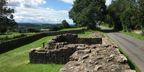
Brougham Castle is an imposing and interesting 13th century castle in a picturesque setting on the banks of the River Eamont. Although mostly ruined there is still plenty to see including the old keep which you can climb to give some lovely views across the surrounding countryside. The castle is actually built on an old Roman fort and the outline of the remaining fort foundations can be seen in the field to the south. The castle and riverbank also provide a good place for a family picnic. Just downstream is the historic Brougham Castle bridge, built in 1812 and repaired in 2017 after almost being washed away during storm Desmond in December 2015. At the castle entrance there is a small shop, toilets and an exhibition giving more information on the history. Open daily from Easter to November, otherwise weekends only. English Heritage property, free admission for members, otherwise admission fee applies. Free car parking on the roadside.
Travelling
Return to the B6262 junction and turn right. Continue for approx 0.8 miles and the historic walls of Brougham Hall are on the left. Take the left immediately before the walls and follow signs to the right for parking behind the Hall.
Brougham Hall

Distance: 42.2 miles
Location: Brougham Hall
Coordinates: N 54.64831, W 2.73221
The former home of the Brougham family, Brougham Hall is a 14th century building with a long and interesting history. The buildings are currently undergoing major renovation after becoming derelict in the last century but you can still see some of the old structure including the massive outer walls and St Wilfred’s Chapel across the bridge over the road. Prior to becoming derelict, the Hall was known as the ‘Windsor of the North’ as the royal family often stayed here in the 19th century. The site is normally open daily and also houses a number of small businesses, a cafe and toilets. There is no admission fee but a donation is welcomed. Free parking behind the Hall.
Travelling
Return to the B6262, turn left and descend past to the Hall to a T junction with the A6 where you turn right towards Penrith. The road immediately crosses the River Lowther and just beyond on the left is King Arthur’s Round Table. Parking is in the layby on the right.
King Arthur's Round Table

Distance: 42.6 miles
Location: King Arthur’s Round Table
Coordinates: N 54.64810, W 2.73927
Despite the name, the prehistoric henge of King Arthur’s Round Table has nothing to do with the legendary King Arthur, preceding his time by a few thousand years. There isn’t much to see now apart from the circular ditches which are interesting but unfortunately not quite complete due to the adjacent road covering part of it. It is believed there was at one time a stone circle but that has long gone. Free roadside parking and access but no facilities on site.
Travelling
Continue on the A6 where you immediately meet a mini-roundabout. Turn left here on the B5320 towards Pooley Bridge and in a short distance take the second right turn towards Mayburgh Henge. On the left just after the turn is the Eden Millennium Monument which is a 50 tonne block of granite placed to commemorate the Eden Millennium Festival in 2000. Continue a short distance along this road to a layby parking area on the left, just where the road bears sharply right. Park here and walk 100m further along the road to Mayburgh Henge on the right.
Mayburgh Henge

Distance: 43.0 miles
Location: Mayburgh Henge
Coordinates: N 54.64722, W 2.74519
The prehistoric Mayburgh Henge is probably related to nearby King Arthur’s Round Table, with both estimated to be about 4000 years old. However, this is significantly more impressive. It is estimated that over 5 million cobbles from the local river were used in the construction and it is mind boggling to imagine how much effort was involved. The outer bank is several metres high and approx 100m diameter and provides good views of the surrounding area. A single upright stone exists in the centre of the arena which is all that remains of the original standing stones. This site and King Arthur’s Round Table were part of a select few English sites included in the Ancient Monuments Protection Act of 1882. Free roadside parking and access but no facilities on site.
Travelling
Return to the T junction at the Eden Millennium Monument and turn left. At the following mini-roundabout turn left on the A6 towards Penrith. Immediately pass the Crown Hotel and the Beehive Inn and continue through the village of Eamont Bridge and over the River Eamont on the old narrow bridge with traffic lights. Before the M6 was built, this bridge was on the main route to Scotland and used to cause horrendous traffic jams but it’s a lot less busy now. Shortly you meet a big busy roundabout which is the A66/A6 junction. Stay in the left lane to take the second exit following the A6 and enter Penrith town. Continue approx 0.7 miles to the market square where the road bears left and up the hill. At the top of the hill is the mini-roundabout adjacent to the Castle which featured at the start of the drive. Take the second exit and then second exit at the following Morrisons mini-roundabout. Drop down the hill a short distance and Bluebell Lane car park is signposted on the right.
Penrith

Distance: 45.0 miles
Location: Penrith, Bluebell Lane car park
Coordinates: N 54.66496, W 2.75523
Return to start point.