Cockermouth - Whitehaven - Maryport drive
A drive of contrasts that encapsulates all that is West Cumbria. From the natural beauty of Lorton Vale and Ennerdale to the industrial heritage of the West coast with its interesting towns, landscapes and coastal scenery. 54 miles.
Route Map
Summary of main attractions on route
| Distance | Attraction | Car Park Coordinates |
| 0 miles | Cockermouth | N 54.66376, W 3.36079 |
| 6.8 miles | Lanthwaite Wood | N 54.58153, W 3.31840 |
| 8.0 miles | Loweswater | N 54.57707, W 3.34052 |
| 13.3 miles | Cogra Moss | N 54.56583, W 3.41652 |
| 17.7 miles | Ennerdale Water | N 54.52487, W 3.41480 |
| 20.3 miles | Kinniside Stone Circle | N 54.51290, W 3.45370 |
| 28.7 miles | Whitehaven | N 54.54760, W 3.59209 |
| 35.7 miles | Harrington Harbour | N 54.61171, W 3.57042 |
| 39.2 miles | Workington shore | N 54.65114, W 3.57685 |
| 41.0 miles | Workington | N 54.64247, W 3.54744 |
| 46.6 miles | Maryport Coastal Park | N 54.70517, W 3.50864 |
| 47.3 miles | Maryport | N 54.71331, W 3.50269 |
| 54.8 miles | Cockermouth | N 54.66376, W 3.36079 |
The attraction car park coordinates are available as Points Of Interest (POI) files for your sat nav device. Use the following link to download a zip file containing the most common POI file formats; Cockermouth – Whitehaven – Maryport POI. Further information on sat nav files can be found on the Navigation page.
The Drive
Cockermouth

Distance: 0 miles
Location: Cockermouth, Bitterbeck car park
Coordinates: N 54.66376, W 3.36079
Cockermouth is an ancient market town, formerly a Roman settlement at an important road and river crossing. The nearby Roman Fort of Papcastle is testament to the Roman activity in the area. The Rivers Derwent and Cocker meet in the town and between them drain a huge area of the northern Lake District. The attractive town was devastated by flood waters in 2009 and 2015 when several feet of flood water flowed along the main street. Since then the town has largely been restored and improved and is well worth exploring.
The pretty main street has a number of interesting shops and Georgian buildings including Wordsworth House where the famous poet William Wordsworth was born in 1770 and spent much of his childhood. The National Trust property is open daily from Easter to November, except Thursdays & Fridays. At the other end of the main street, off Castlegate, is Cockermouth Castle, some of which dates from the 12th century but is privately owned and rarely open to the public. Other attractions include Castlegate House Gallery, Market Place and some pleasant riverside walks. Pay and display car park with toilet facilities.
Travelling
Turn right out of the car park to meet Market Place at a T junction. Turn right and in only 80m turn right again on Kirkgate which is a narrow opening between buildings. The old lane climbs past the Bitter End Pub & Brewery on the left and soon widens with attractive Georgian properties overlooking the cobbled area on the left. At the top of the hill there are two T junctions in quick succession and you effectively go straight ahead at each to join the B5292 Lorton road. Continue south-eastwards, through the outskirts of the town and soon enter open country. Lorton Vale is one of the most picturesque valleys in the Lakes and you can certainly appreciate it from the road. In the distance you can see some mighty peaks at the head of the valley. Continue on the narrow road to Low Lorton village where the Whatsheaf Inn is on the left. In a further 3 miles, the road descends steeply towards the River Cocker and just before the bridge, Lanthwaite Wood car park is on the left.
Lanthwaite Wood, Crummock Water

Distance: 6.8 miles
Location: Lanthwaite Wood, Crummock Water
Coordinates: N 54.58153, W 3.31840
Lanthwaite Wood is an attractive woodland area which gives pedestrian access to the shores of Crummock Water and some fabulous views up the lake. From the car park, follow the peaceful forest road which leads approx 0.5 miles through woodland to the lakeshore. The shingle beach is backed by trees and has a well placed bench with wonderful views up the lake. From here it is possible to walk the 8 mile circuit of Crummock Water. Alternatively, approx 0.3 miles along the left shore leads to a pretty boathouse, again with good views, or a slightly longer walk along the right shore leads over the outflow to the River Cocker, past a water company pump house to a wonderful large shingle beach with even better views. National Trust pay and display car park with no facilities.
Travelling
Exit the car park and turn left towards Loweswater. Continue through some very pleasing countryside surrounded by mountains for approx 0.5 miles to a red telephone box on the left. Turn left here for a short detour towards the popular Kirkstile Inn which has its own microbrewery and provides refreshments in a glorious setting. Adjacent is St Bartholomew’s Church, again in a lovely setting. The minor road loops back to the main valley road where you turn left. After approx 0.2 miles take the very minor turn on the left which leads down a narrow dead-end lane approx 0.3 miles to the small Maggie’s Bridge car park.
Loweswater

Distance: 8.0 miles
Location: Loweswater, Maggie’s Bridge car park
Coordinates: N 54.57707, W 3.34052
Loweswater is a relatively small, remote and beautiful lake which is worth exploring. With no developments around its shores, the lake is very peaceful and is surrounded by some wonderful mountains and scenery. A lovely level walk leads from the car park along a well made track a short distance to the lakeshore and continues into Holme Wood on the southern shore. This pretty woodland area is one of the few remaining strongholds of the red squirrel and also includes Holme Force waterfall set high above the lakeshore which can be reached by additional paths. A rougher path continues to the head of the lake and a 3.5 mile lake circuit can be achieved by walking back along the road. Free car park but only has a few spaces and can be busy. No facilities.
Travelling
Return to the main valley road and turn left. The narrow road descends towards Loweswater and there are good views of the lake and its impressive mountainous backdrop. Soon enter a wooded section along the lakeshore. Views are limited by trees and there is very little parking but if you’re lucky you might see a rare red squirrel. The road then climbs away from the lake and views open up again. There are two large free layby parking areas, the second one with a telephone box offers some good views and access to the lakeshore footpath.
Beyond the lake the road climbs and soon passes through a sharp left turn and over a summit. The road then descends with good open views towards the coast and southern Scotland before entering the village of Lamplugh where you meet a T junction and turn left. Soon pass St Michael’s Church on the right, the road descends for approx 0.3 miles where you take a left turn towards Ennerdale Lake. Continue on the narrow bendy road for approx 0.5 miles to Lamplugh Felldyke car park on the left.
Cogra Moss

Distance: 13.3 miles
Location: Cogra Moss, Lamplugh Felldyke car park
Coordinates: N 54.56583, W 3.41652
Cogra Moss is a small reservoir and forest, tucked away in a remote corner of the Lake District, but still spectacular with the attractive reservoir backed by some impressive forested slopes and mountains. Although not used for water supply since the mid 1970’s, it remains a wonderful amenity that is worth a visit. From the car park, a short path then a good track lead approx 0.5 miles to the reservoir. The track rises slightly, giving great views towards the coast and southern Scotland, before descending to the reservoir dam and shore. There are some benches along the shore from where you can appreciate the views, or you can continue on a footpath around the reservoir, or up into the surrounding forest. The reservoir is popular for fishing but always tranquil. Small free car park but no facilities. A bench adjacent to the car park is dedicated to one of the local victims of the Cumbria shootings in 2010.
Travelling
Turn left out of the car park and continue along the narrow road with good open views. Before long, fabulous views of Ennerdale lake and valley open up ahead and the road starts to descend in that direction. At the foot of the descent meet a minor T junction and turn right. The road becomes single track with passing places and meanders between hedges for a short distance before becoming a bit wider with some glimpses of Ennerdale lake on the left. Soon meet a wooded section on the left which is Broadmoor Forest. Continue a short distance to take a left turn signposted to Ennerdale Lake. Drive through Broadmoor Forest for approx 0.7 miles and cross the River Ehen to meet Bleach Green car park on the left.
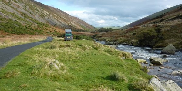
Ennerdale Water

Distance: 17.7 miles
Location: Ennerdale Water, Bleach Green car park
Coordinates: N 54.52487, W 3.41480
Ennerdale Water is the most westerly and most peaceful of all the Lake District lakes. Due to its remoteness and lack of development it gets relatively few visitors but it is certainly a beautiful lake and location. There are no public roads around the lake, but two car parks nearby and the one at Bleach Green gives easiest pedestrian access. From the car park, follow the good footpath through the trees and along the track for approx 0.2 miles to the lakeshore. At the lake you will see the river outflow weir and fish pass along with some fabulous views up the lake towards the mountains beyond. The grassy area nearby to the right is ideal for a picnic and paddle. There is a lovely path around the lake which is 6.5 miles in total, or shorter walks are possible. The picturesque and very remote Ennerdale valley continues for several miles beyond the lake and is home to the Wild Ennerdale Partnership which seeks to “allow the evolution of Ennerdale as a wild valley for the benefit of people, relying more on natural processes to shape its landscape and ecology.” You can walk or cycle along the forest track up the valley which eventually reaches Black Sail Youth Hostel, surrounded by mountains. Free car park with no facilities.
Travelling
Retrace your steps back out of Broadmoor Forest and turn left at the T junction. Very shortly enter the village of Ennerdale Bridge and continue to the T junction in the village centre. Nearby to the right is the Shepherds Arms Hotel. Turn left at the T junction towards Whitehaven. Cross the River Ehen again and on the right is a playground, St Mary’s Church, the Fox & Hounds pub and The Gather cafe & shop. Continue out of the village and take the first left towards Gosforth. Continue approx 0.8 miles to cross a cattle grid on to open moorland and approx 0.2 miles beyond is Kinniside stone circle on the left.
Kinniside Stone Circle

Distance: 20.3 miles
Location: Kinniside Stone Circle
Coordinates: N 54.51290, W 3.45370
Kinniside stone circle is an impressive monument, not just because of the ancient stones but also the wonderful surrounding views. The relatively small circle has clearly been reconstructed in modern times as the 11 stones are set in concrete, but these are apparently the original stones in the original positions. The circle is in a picturesque open moorland setting with distant views towards the west coast and also over the surrounding hills. The circle is adjacent to the road allowing easy access. There is free roadside parking and entry but no facilities.
Travelling
Retrace your steps back 1 mile to the T junction and turn left towards Whitehaven. Continue through open countryside for just over 2 miles to cross the River Ehen on an old narrow bridge where there is a pleasant grassy area overlooking the river with a few benches. Beyond this the road climbs to a T junction with the main A5086. Turn right then immediate left on the B5295. Pass through the town of Cleator Moor, which built up in the 19th century around local coal mines and iron works. Not the most attractive place but there are various shops in the town.
Beyond Cleator Moor there is some open country before entering the outskirts of Whitehaven. Soon, meet a mini-roundabout, take the first exit and descend to another mini-roundabout where you take the second exit. Shortly, take the right lane at the traffic lights to turn right on the main A595. Immediately get in the left lane to take the A5094 towards Whitehaven town centre. After approx 0.5 miles, pass straight through the first traffic lights, then take the right lane at the second traffic lights to continue towards Town Centre. On the left is a retail park and on the right is an impressive building known as Whitehaven Castle, although it is now a private residence. Soon meet further traffic lights and turn left, then at the next traffic lights turn right. After approx 150m, Quay Street car park is on the left.
Whitehaven

Distance: 28.7 miles
Location: Whitehaven, Quay Street car park
Coordinates: N 54.54760, W 3.59209
Whitehaven is an attractive coastal town with an interesting history and a number of attractions for visitors. The town grew up in the 17th & 18th centuries with the boom of local coal mining and the port soon became one of the most important in the country for coal export. The Georgian town was largely planned and built during this boom and the grid patterned streets were quite unique at the time. The coal mines eventually closed and the port became redundant but the harbour area has been redeveloped in recent times as a marina and tourist attraction and is worth exploring.
The Beacon museum is on the harbour side and tells the history of the local area. In the town itself the Rum Story attraction tells the darker history of the area and nearby is St Nicholas’ Church which was largely destroyed by fire in 1971 but the tower and pretty gardens are open to the public. Buried here is Mildred Gale, the grandmother of first US President George Washington, who briefly lived and died in the town. Up the nearby hill is St James’ Church which has a beautiful Georgian interior. Pay and display car park.
Travelling
Leave Quay Street the way you came in, turning left at the T junction. The road follows the harbour, one block away, and soon becomes one-way. Stay in the left lane to continue northwards. As the road becomes two-way again, pass a Tesco supermarket on the left and continue uphill away from Whitehaven town centre. The road soon joins the main A595 with some sea views. Shortly, on the left you can see the imposing St Bridget’s Church which is also the site of an old Roman Fort at Moresby. The historic Moresby Hall is adjacent. Just beyond, meet a large roundabout and take the first exit which is the A595 Distington bypass.
Continue along the dual carriageway for approx 2.5 miles to another roundabout and take the first exit, A597, towards Harrington. Soon enter High Harrington and take the first exit at the Galloping Horse mini-roundabout. The road generally descends for approx 0.5 miles to pass St Mary’s Church on the right. Just beyond, take the first left turn at the pedestrian crossing and pass through Harrington village where there is a post office and shop. Continue under the low railway bridge and see the harbour on the right. Just beyond is a toilet block on the right where you turn immediate right and parking is at the end of this dead end road.
Harrington Harbour

Distance: 35.7 miles
Location: Harrington Harbour
Coordinates: N 54.61171, W 3.57042
Similar to many other west coast recreational sites, Harrington harbour was once a hive of industrial activity that has since been cleared and landscaped to leave a pleasant coastal access area with good sea views. Harrington town grew up around the harbour which was built for coal export in the mid-18th century. Various industries also flourished including coal mines, iron works, steel making and ship building. All that disappeared with the decline in the manufacturing industry and the town is a shadow of its former self but the harbour area provides a good open space to explore and stretch your legs. The old harbour is still mostly intact and there is a large expanse of open grass where you can walk some distance along the coast. The mostly stony beach is backed by a sea wall and there are fine views out to sea towards southern Scotland and the Isle of Man. Free car park with nearby toilet facilities and playground.
Travelling
Retrace your steps back under the railway bridge and through Harrington to the T junction where you turn left on the A597. Continue through the outskirts of Workington for approx 0.8 miles and head straight across a mini-roundabout at Asda. In a further 0.8 miles meet a larger roundabout where you take the first exit. Pass a retail park on the right and continue straight ahead at two mini-roundabouts to meet a T junction where you turn left. Soon cross an old railway line and turn immediate right. To the right are views over the mouth of the River Derwent and Workington Port. At the end of the road the car park is on the left.
Workington shore

Distance: 39.2 miles
Location: Workington shore
Coordinates: N 54.65114, W 3.57685
Another pleasant but once industrial coastal access area which has good views in all directions, coastal walks and a beach. The open, mostly grassy land forms a promontory guarding the mouth of the River Derwent and you can watch activities across the river at the still operational Workington Port. The river itself drains a large portion of the northern Lakes so can get very high. The site also offers good views southwards towards St Bees Head, northwards beyond the many wind turbines, out to sea towards southern Scotland and the Isle of Man, plus inland towards the Lake District mountains. There are good paths along the cliff tops immediately to the south giving even better views. The beach is mostly stony at high tide but exposes an expanse of hard sand at low tide. Free car park but no other facilities.
Travelling
Retrace your steps to the T junction and turn left. Cross the old railway line again and continue approx 0.5 miles to cross a railway bridge and take the right lane as you approach the T junction. Turn left on the one-way system and stay in the right lane around the island to take the second exit for B5297, Town Centre. Continue along this road for approx 0.5 miles to a mini-roundabout where you take the third exit. Very shortly take the first left turn and Central car park is on the left.
Workington

Distance: 41.0 miles
Location: Workington, Central car park
Coordinates: N 54.64247, W 3.54744
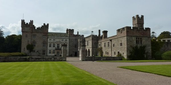
Workington, like many other local towns, grew up largely around the coal industry and had a significant boom around the 18th century. Again there were dozens of coal mines in the area, some extended out to sea underground and the town also became a centre for steel making. Although it eventually became a significant port, the old town was on higher ground slightly inland. This old town area, slightly east of the shopping centre, is an interesting place to explore and includes the attractive Portland Square, the striking St John’s Church and the Helena Thompson Museum which reflects the history of the area. Curwen Park contains the impressive ruins of Workington Hall which was the home of the Curwen family who helped develop the area during the boom years. For some retail therapy, the town centre has plenty to offer including Washington Square shopping centre which has a number of popular high street stores. Pay and display car park.
Travelling
Turn right out of the car park and right at the following T junction which returns to the mini-roundabout where you take the second exit, continuing on the B5297. Very shortly, take the left turn at the traffic lights, then straight ahead at the next traffic lights, towards Maryport on the A596. The road descends away from the town centre to cross the River Derwent on Workington Bridge. At the roundabout take the first exit to follow the river and soon pass under Northside Bridge, built to replace the one that was destroyed during the devastating November 2009 flood. At the roundabout take the second exit, A596 towards Maryport. Soon pass Dunmail Park shopping centre on the right and continue passing various industrial sites and wind turbines. There are limited sea views as you pass Flimby village and not far beyond, take the first left turn signposted to Tourist Attractions. Approx 100m on the left is Maryport Coastal Park car park.
Maryport Coastal Park

Distance: 46.6 miles
Location: Maryport Coastal Park
Coordinates: N 54.70517, W 3.50864
This undulating coastal park covers quite a large area, running approx 1 mile southwards from Maryport harbour. This car park gives access towards the centre of the park and the coast is only a couple of minutes walk along a decent path. The open grassy area is another old industrial site made good and there are coastal paths leading in both directions. There are great views out to sea towards southern Scotland and each way along the coast. The beach is mostly stony at high tide but exposes a large expanse of hard sand at low tide. Free car park but no other facilities.
Travelling
Leave the car park and turn left. Shortly, take the first exit at the industrial estate roundabout and continue approx 0.4 miles, passing through the outskirts of Maryport and alongside the River Ellen to The Wave Centre on the right. Irish Street car park is opposite on the left.
Maryport

Distance: 47.3 miles
Location: Maryport, Irish Street car park
Coordinates: N 54.71331, W 3.50269
Maryport is another West Cumbrian town that largely developed during the 18th century due to the local coal boom. Like Whitehaven, the town was developed with a grid patterned street design centred on the busy harbour and on Fleming Square which remains an attractive cobbled square surrounded by Georgian architecture. The industry is long gone but the pleasant harbour area has been redeveloped in recent years and is worth exploring. You can learn about the interesting history of the area at The Maritime Museum and nearby is The Lake District Coast Aquarium which is a good family attraction. The Wave entertainment centre has various attractions and a cafe. Pay and display car park with toilet facilities.
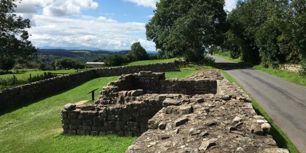
Long before the coal boom, the town was also a Roman settlement with defences which extended from Hadrian’s Wall down the west coast. On the hill at the northern end of the town are the remains of a Roman Fort adjacent to the Senhouse Roman Museum which contains interesting Roman artefacts. The Roman Fort area has some wonderful views across the harbour and out to sea towards southern Scotland, as does the promenade below which provides a good walk along the sea front.
Travelling
Leave the car park and turn left. Very shortly take the right turn to cross the River Ellen and proceed up the small hill to turn left where ahead is no entry. Continue past a Post Office to turn right at the next T junction. The road descends through the town to traffic lights at a crossroads by St Mary’s Church where you continue straight ahead on the A594 towards Cockermouth. Shortly, go straight across a mini-roundabout and pass through town suburbs before the road climbs away from Maryport and enters the village of Dearham. The village contains the ancient church of St Mungo’s and a popular pie shop, Cottage Pie, on the right alongside the A594.
Continue on the A594, good views soon open up ahead towards the Lake District mountains. In a further 2 miles enter Dovenby village with the Ship Inn on the left. Just beyond on the right is Dovenby Hall, home to the Ford World Rally Team. Continue approx 1.3 miles to a roundabout and take the second exit, A5086 to Cockermouth. The road descends to meet the outskirts of Cockermouth and you cross over the River Derwent to a mini-roundabout. Take the first exit towards Cockermouth town centre, then straight ahead at another mini-roundabout to pass along the attractive Main Street. As the road becomes narrower, cross over the River Cocker and just beyond turn right to Market Place. Almost immediately, turn right again to Bitterbeck car park.
Cockermouth

Distance: 54.8 miles
Location: Cockermouth, Bitterbeck car park
Coordinates: N 54.66376, W 3.36079
Return to start point.