Coniston - Duddon Valley - Eskdale drive
A drive that includes the most challenging mountain pass roads in the Lake District along with some remote and beautiful scenery. The drive also visits a number of historic attractions and allows a glimpse of bygone industry in the area. 42 miles.
Route Map
Summary of main attractions on route
| Distance | Attraction | Car Park Coordinates |
| 0 miles | Coniston Village | N 54.36892, W 3.07347 |
| 0.8 miles | Coniston Water | N 54.36460, W 3.06779 |
| 10.5 miles | Broughton in Furness | N 54.27781, W 3.21128 |
| 11.8 miles | Duddon Iron Furnace | N 54.28424, W 3.23474 |
| 14.5 miles | Duddon Valley access area | N 54.31561, W 3.23108 |
| 21.7 miles | Forge Bridge access area | N 54.38395, W 3.31215 |
| 23.7 miles | Trough House Bridge | N 54.39141, W 3.27796 |
| 24.1 miles | Dalegarth Station & Boot | N 54.39505, W 3.27460 |
| 27.5 miles | Hardknott Roman Fort | N 54.40241, W 3.20163 |
| 28.2 miles | Hardknott Pass | N 54.40290, W 3.18488 |
| 31.6 miles | Wrynose Pass | N 54.41495, W 3.11520 |
| 39.4 miles | Tilberthwaite access area | N 54.39972, W 3.07000 |
| 42.0 miles | Coniston Village | N 54.36892, W 3.07347 |
The attraction car park coordinates are available as Points Of Interest (POI) files for your sat nav device. Use the following link to download a zip file containing the most common POI file formats; Coniston – Duddon Valley – Eskdale POI. Further information on sat nav files can be found on the Navigation page.
The Drive
Coniston
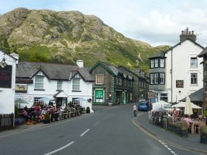
Distance: 0 miles
Location: Coniston Village car park
Coordinates: N 54.36892, W 3.07347
The village of Coniston is in a picturesque location nestled between Coniston Water and The Old Man of Coniston, the mountain directly behind. Historically, it grew up due to the local copper and slate mines which flourished from the 17th century with workers being housed in the village. In 1859 a railway line was opened to the village from the main Cumbrian Coast line near Broughton in Furness. The main purpose of this at the time was to transport the copper ore, but as copper demand declined in the late 19th century the railway line became more popular with Victorian tourists. A local tourist industry soon grew up which has become more and more popular over time. The railway closed in 1962 and there is little trace of the old line and station now but it certainly helped to put Coniston on the map in its heyday.
Probably the most notable local resident was John Ruskin, the famous Victorian visionary, artist, art critic and writer, who lived nearby at Brantwood on the shores of Coniston Water from 1871 until his death in 1900, aged 80. He was buried at St Andrew’s Church in the centre of the village. Following his death, the Ruskin Museum was established in Coniston in 1901 and is still going strong today, containing a wealth of local history.
The village itself has a few tourist shops, cafes and pubs where you can spend some time and fully appreciate the surrounding scenery. The car park is pay and display with a Tourist Information Centre and toilet facilities.
Travelling
From the village car park, turn left and continue on the B5285 which shortly meets the A593 at a T junction in the village centre. Turn left, over the river and past a service station & shop, then immediately take Lake Road on the left which leads 0.5 miles down to the lake. The car park is just before the lake on the left.
Coniston Water, Lake Road

Distance: 0.8 miles
Location: Lake Road car park, Coniston Water
Coordinates: N 54.36460, W 3.06779
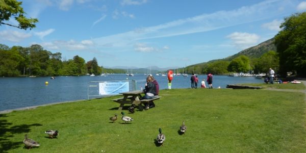
Coniston Water is a scenic and relatively quiet lake surrounded by low and mostly wooded hills. It is well worth taking a trip on the lake to better appreciate the scenery and you can do this either on the historic Steam Yacht ‘Gondola’ or the Coniston Launch. If you fancy hiring a boat yourself, the Coniston Boating Centre is adjacent to the car park with a good selection of small boats and paddle boards. Across the lake, you can just about make out Brantwood house where John Ruskin the famous Victorian visionary, artist, art critic and writer, lived from 1871 until his death in 1900. You can visit the house and gardens via the Gondola or Launch boats which both stop at the jetty near the house.
The lake also has famous literary connections through the popular children’s adventure book ‘Swallows and Amazons’, written by the author Arthur Ransome and published in 1930. The book is based on a number of locations around the lake, for example, Wild Cat Island in the book is said to be based on Peel Island towards the southern end of the lake.
Perhaps the most famous moment in the lake’s history came on 4th January 1967 when Donald Campbell lost his life on the water during a world record water speed attempt. Film footage shows the boat summersault and break up but it was not until 2001 that his body was discovered on the bed of the lake and laid to rest in Coniston cemetery. The battered boat was also raised and taken away for restoration, but subsequently caught up in a legal battle of ownership for many years and not on show. All that changed in March 2024 when it was returned to Coniston and is now on show in the ‘Bluebird Wing’ of the Ruskin Museum in Coniston village.
You can learn more about ‘The Campbells on Coniston’ and about ‘Swallows and Amazons’ at the Ruskin Museum in the village and also on themed cruises around the lake aboard the Gondola or the Launch.
Also next to the car park and shore here is The Bluebird Cafe which provides refreshments with a lovely view over the water and there are several picnic tables adjacent. The car park is pay and display with toilet facilities.
Travelling
Return back up Lake Road and at the top turn left on the main A593. The route now follows the A593 to Broughton In Furness. You soon leave the main village of Coniston and the road starts to climb with some views across Coniston Water. Shortly, you pass through a small settlement where the Ship Inn is on the right. The pleasing road runs parallel with the lake but views are limited by trees. You soon enter the village of Torver which doesn’t have much to offer visitors apart from the Church House Inn on the left and the Wilsons Arms & Torver Deli on the right. Continue on the A593 beyond Torver and the road soon becomes quite narrow and winding. After a small climb, the road continues down the valley with good views of the surrounding low hills and ahead towards the Duddon Estuary. Just over 6 miles from Torver, enter the town of Broughton In Furness and soon meet a T junction at the main Square where there are a number of parking spaces.
Broughton In Furness

Distance: 10.5 miles
Location: Broughton In Furness
Coordinates: N 54.27781, W 3.21128
Broughton in Furness is a peaceful town with an attractive central Square and some interesting historical features. This old market town has a long history and the Tourist Information Centre is now housed in the old Town Hall overlooking the old Market Square. The obelisk in the centre of the Square was erected to mark the golden jubilee of King George III in 1810. The adjacent stocks are a reminder of what happened to miscreants in bygone days!
The town is far enough away from the central Lakes not to attract masses of visitors but is worth exploring. The town centre has a few small shops and three pubs for refreshments. Public toilets can be found just off the north east corner of the main Square and just beyond these is Wilson Park which provides a good open area of grass for recreation. Beyond the park are some pleasant easy walks, including the old railway line towards Coniston.
Parking in and around the main Square is free.
Travelling
Leave the Square by the road adjacent to the Manor Arms, then take the immediate right turn (Brade Street). Turn right again at the end of this road and continue for a short distance, passing the Black Cock Inn on the right. Turn left at the T junction immediately after the pub. The road passes the Old Kings Head Inn on the left and continues up the hill, out of the town and soon meets the main A595 at a T junction. Turn right on the main road towards Ulpha. The road drops down a steep hill and shortly approaches some traffic lights at a narrow bridge over the River Duddon. The drive takes the right turn to Ulpha just before the lights, but if you want to see Duddon Iron Furnace, continue over the bridge and take the first right turn alongside the river. Approx 100m along this road is the entrance to Duddon Iron Furnace car park through a gate on the left.
Duddon Iron Furnace

Distance: 11.8 miles
Location: Duddon Iron Furnace
Coordinates: N 54.28424, W 3.23474
Duddon Iron Furnace operated from 1736 to 1867 and is a fine example of historic industry in the area. Close to, but well hidden from the road, this impressive old furnace site is well worth a visit. The site is only a few metres along the track from the road and is free entry with apparently no visiting restrictions. A plaque by the entrance gate tells you more about the site which claims to be ‘one of the most impressive charcoal fired blast furnaces in Britain’. The buildings are still in relatively good condition and you are free to wonder around at your leisure. Free parking but no facilities.
Travelling
Turn around to retrace your steps back over the narrow bridge at the traffic lights. Immediately after the bridge take the left hand turn to Ulpha. This is now the Duddon Valley road which is quite narrow and winding but very scenic. Initially, there is a short steep climb but as the road levels out there are wonderful views of surrounding craggy hills, covered in either bracken or trees. After approx 1.5 miles, cross a cattle grid and enter an open section which starts descending towards the river. Soon, the road meets the river and there are a number of layby parking areas where access to the river can be gained.
Duddon Valley access area

Distance: 14.5 miles
Location: Duddon Valley access area
Coordinates: N 54.31561, W 3.23108
A fabulous open access area adjacent to the road and the River Duddon. There are plenty of good grassy areas inbetween the bracken which are ideal for a picnic next to the river. The shallow, crystal clear water with small pools and cascades is perfect for a paddle on a good day and there are fine views of the surrounding hills. The Duddon Valley was also a favourite of the famous poet William Wordsworth, in 1820 he published “The River Duddon, A Series of Sonnets”. The access from the road is naturally a little rough but relatively easy. Free roadside parking but no facilities on site.
Travelling

Continue along the minor road up the Duddon Valley. In a short distance you enter the small settlement of Ulpha where the road crosses the river. There’s not much in Ulpha but soon after the bridge on the right is St John the Baptist Church which is in a lovely position next to the river and is normally open to visitors.
Shortly after the church, take the left turn to Eskdale up the Birker Fell road. The sudden steepness of this narrow road is quite a shock after the gentle valley floor and the first section is as steep as any road in the area. The gradient soon eases and you travel across Birker Fell with its wide open spaces and views of distant hills. As the road reaches its summit, the views ahead towards Scafell and surrounding peaks are wonderful and well worth a quick stop to fully appreciate. From here the road descends quickly to Eskdale valley. Soon pass a minor road junction on the left and just less than half a mile beyond this is Forge Bridge access area on the left, just before the bridge itself.
Forge Bridge access area

Distance: 21.7 miles
Location: Forge Bridge access area
Coordinates: N 54.38395, W 3.31215
This is a small open access area on the wonderful River Esk. It isn’t ideal for a picnic with very little grass or seating but there is a good expanse of stone/shingle and a nice clear pool in the river for paddling and bathing, just downstream of the old bridge. There is free parking in the adjacent layby and the river is immediately through the stile in the wall. There are no facilities on site.
Travelling
Continue over Forge Bridge and shortly you see the King George IV Inn on the left which provides refreshments in a lovely setting. Take the right turn opposite the pub towards Boot. Follow the picturesque valley floor road which soon follows the River Esk on the right and the miniature Eskdale Railway on the left. If you are lucky you may see one of the small trains rattling along. Approx 1.5 miles from the pub, pass the small Beckfoot station on the left and approx 0.2 miles further on, opposite some buildings, take a minor right turn. Continue 0.2 miles over Trough House Bridge and the car park is shortly on the left.
Trough House Bridge

Distance: 23.7 miles
Location: Trough House Bridge car park
Coordinates: N 54.39141, W 3.27796
This small car park gives good access to a couple of natural wonders. Firstly, back towards the road bridge, is Trough House Bridge access area which is quite a small rocky and wooded riverbank where the River Esk passes underneath the bridge via a deep gorge. The water immediately downstream of the bridge is very deep and clear and ideal for bathing. Further downstream is some shallower water for paddling.
Secondly, is Stanley Force waterfall which is just over half a mile walk from the car park. The path continues along the track from the car park. Once you meet Stanley Ghyll, the path becomes narrower and rougher as it heads into the impressive narrow canyon with high rocky cliffs and precariously perched trees. From 2019, a lot of work has been done to clear the canyon of excess vegetation and improve access. You can only get as far as the second bridge now, with glimpses of the waterfalls ahead, before the path heads steeply up to the cliff tops above. Here, you will find a quite unexpected and spectacular metal viewing platform, which hangs out over a vertigo inducing 150 foot drop and gives wonderful views over the canyon and beyond towards Boot village and Scafell mountain. Free car park but no facilities.
Travelling
Return to the T junction at the main valley road and turn right towards Boot. In 0.2 miles is Dalegarth Station on the left and the car park turn is immediately before the station.
Dalegarth Station & Boot

Distance: 24.1 miles
Location: Dalegarth Station car park
Coordinates: N 54.39505, W 3.27460
Dalegarth Station is the terminus for the miniature Ravenglass & Eskdale Railway and is often a hive of activity with regular trains coming and going during the summer (less so during the winter). The line was originally opened in 1875 to transport Iron Ore down the valley but is purely for tourists nowadays. A ride on the small train is a great way to see the picturesque valley with several minor stations along the way and you can continue to the coast at Ravenglass which is about 7 miles away. If you don’t fancy a train ride, it is still fascinating to watch the small steam engines at work, especially on the small turntable where they turn around for the trip back down the valley. The car park is pay and display with some picnic tables by the river and a small play area. The station building has a cafe and toilets.

Dalegarth Station car park is also the best place to park for a visit to Boot which is approx 0.3 miles walk along the road. It is a pretty little village in a picturesque setting with a small shop and a couple of pubs providing refreshments at the Boot Inn and the Brook House Inn. At the far end of the village, over the ancient packhorse bridge, is the fascinating Eskdale Mill which still maintains its historic working machinery and is one of the oldest water powered corn mills in the country.
Walking back out of Boot, towards the main road, if you walk straight across the road a track takes you approx 0.3 miles down to the River Esk where the quaint old church of St Catherine’s is in a lovely secluded riverside setting with some benches from where you can appreciate the surroundings.
Travelling
Turn left out of the station car park to continue up the Eskdale valley beyond Boot. The scenic but narrow valley road soon takes you past the Woolpack Inn pub and cafe, then Eskdale Youth Hostel, followed by Wha House car park, all on the left. Cross the River Esk and a short run along the valley floor with good views of surrounding mountains brings you to the foot of Hardknott Pass, marked by various warning signs and a telephone box. This is the start of a notorious section of mountain road which certainly provides a challenging and often exciting experience. It is not something to try in bad weather and you need to ensure your vehicle is in good working order, you think ahead and hope other drivers do the same! The narrow road with passing places immediately starts to ascend very steeply for half a mile before the gradient eases and you reach the layby parking area for Hardknott Roman Fort on the left.
Hardknott Roman Fort

Distance: 27.5 miles
Location: Hardknott Roman Fort
Coordinates: N 54.40241, W 3.20163
Hardknott Roman Fort was built between AD 120 and AD138 and is situated in a commanding position with fabulous views over Eskdale valley. The old Roman road followed Eskdale valley from the coast, up over Hardknott Pass and on to Ambleside. Although much of the Fort has gone, the foundations above ground still remain and you can see the outline of the buildings and the impressive outer wall. Small plaques around the Fort tell you more. You also get a good view of the slightly daunting road yet to come towards the top of Hardknott Pass. It is a short walk across rough ground to the Fort from the parking area. Free entrance and parking but no facilities.
Travelling
Continue up Hardknott Pass on the narrow road which again becomes very steep with some hair raising hairpin bends. Some care is needed on this section but you soon reach the summit. Just over the summit hump there is a small rough parking area on the left.
Hardknott Pass

Distance: 28.2 miles
Location: Hardknott Pass
Coordinates: N 54.40290, W 3.18488
It is advisable not to look at the views behind you on the way up, but the summit area gives great views back down Eskdale valley and even to the Isle of Man on a good day. In the opposite direction you can see right across the beautiful upper Duddon valley towards Wrynose Pass, which provides the next challenge to your journey. The parking area is small and rough but free. There isn’t a great deal of room to stop at the top and you need to be careful not to block passing places. There are no facilities in the area.
Travelling
Once over Hardknott Pass summit, the road quickly starts to descend and again becomes very steep with plenty of tight corners where you need to be careful of oncoming traffic. The gradient eventually eases and you descend more gradually to Cockley Beck Bridge which crosses the upper River Duddon. Just over the bridge, turn left towards Wrynose Pass along the Wrynose Bottom road. The scenic road follows the river and is literally surrounded by high mountains. There are some larger laybys where you can stop and admire the scenery, but be careful not to obstruct passing places. Approx 1.5 miles from Cockley Beck Bridge, the road begins to ascend Wrynose Pass. Although steep, narrow and winding again, it is not as severe as Hardknott Pass and in a further half a mile you reach the summit.
Wrynose Pass

Distance: 31.6 miles
Location: Wrynose Pass
Coordinates: N 54.41495, W 3.11520
According to the Ordnance Survey map, the road summit of Wrynose Pass at 393m above sea level is exactly the same height as the road summit of Hardknott Pass. Wrynose Pass summit area is a bit more open and level with various free parking areas to the side of the road. Various footpaths lead up the surrounding hills from here and again there are great views in all directions. Just past the summit on the left is the Three Shire Stone which marks the historic meeting point of the old counties, Cumberland, Westmorland and Lancashire. There are no facilities in the area.
Travelling

Continue past the Three Shire Stone and start to descend, steeply at first, towards Little Langdale with good views. Again, not as difficult as Hardknott Pass, it is still a tricky descent with a big drop on the right and needs some caution. The road eventually levels out and goes past Fell Foot Farm which is an attractive historic building owned by the National Trust. Shortly after this, the minor road from Great Langdale joins on the left. Continue straight on, over the cattle grid and along the narrow walled lanes. Little Langdale Tarn can be seen on the right and before long you drop down to the hamlet of Little Langdale with the traditional looking Three Shires Inn on the left.
Beyond Little Langdale, the road generally continues to descend through trees following the River Brathay for approx 1 mile until a T junction is reached. Turn right here towards Coniston. Almost immediately, cross the River Brathay on Colwith Bridge and just beyond this you can park by the road on the left to access the impressive Colwith Force waterfall, a short distance upstream. A rough footpath leads to the waterfall, back towards the bridge and over the stile on the left.

Continue driving up a small but steep ascent to a T junction where you turn right on the main A593. It makes a refreshing change driving on a road with a central white line! The road climbs over a small summit and descends to Yew Tree Tarn on the right which is man-made in a lovely setting with a free layby adjacent. Just beyond that on the left is Glen Mary Bridge National Trust car park and soon on the right is Yew Tree Farm which is a picture book farm once owned by Beatrix Potter. The farmhouse was used as the double for her actual home, Hill Top, in the 2006 film ‘Miss Potter’. The farm now offers Herdwick sheep experiences where you can get up close to these popular animals. Approx 0.5 miles beyond Yew Tree Farm there is a minor road on the right signposted to Hodge Close. Continue beyond this for another 0.1 miles to a second right turn signposted to Tilberthwaite. Take this right turn, although the road doubles sharply back so you will need to take a wide swing. This dead end narrow road with passing places continues up the picturesque valley alongside Yewdale Beck for approx 1 mile until you reach a large open parking area on the left, just before the road crosses the beck.
Tilberthwaite access area

Distance: 39.4 miles
Location: Tilberthwaite access area
Coordinates: N 54.39972, W 3.07000
Tilberthwaite is an attractive and peaceful valley which can be fully enjoyed from this riverside access area. There is a big free car park and directly across the road, a stile takes you to a nice open area of grass next to the river which is ideal for a picnic. This area has a long history of slate mining and the evidence is not difficult to see. The slopes behind the car park are covered with mined slate and the area between here and Little Langdale is a mass of old mine workings. The wide shallow river is also strewn with pieces of old mined slate which might be a hazard if paddling. There is a very pleasant and gentle walk to Little Langdale which continues along the quiet track from the car park. Little Langdale is some distance by road but only about 1.5 miles by footpath. There are no facilities on site.
Travelling
Retrace your steps back to the A593 and turn right towards Coniston. The road continues through the attractive Yewdale valley with craggy and wooded hills on each side for approx 1.5 miles to enter Coniston village. Proceed to the centre of the village and turn left immediately after the Yewdale Inn. After 0.1 miles, take the first right turn and the main car park is immediately on the right.
Coniston

Distance: 42.0 miles
Location: Coniston Village car park
Coordinates: N 54.36892, W 3.07347
Return to start point.